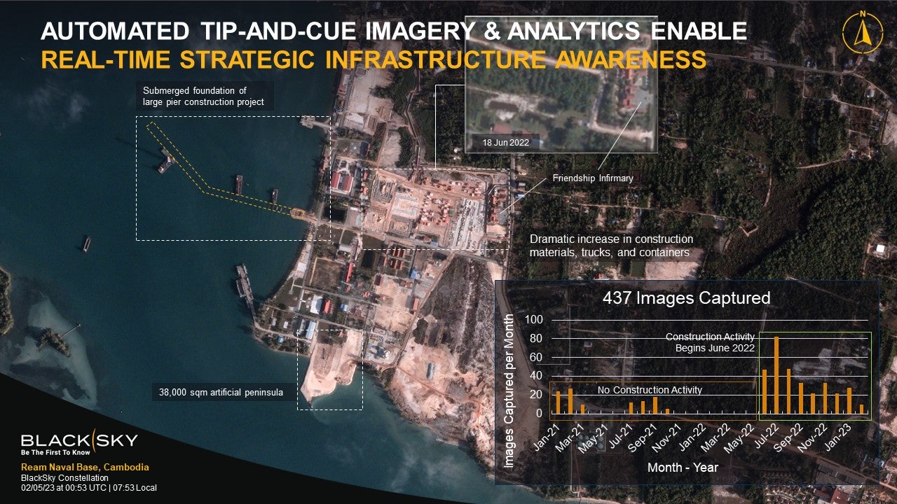
The construction of a secret naval staging facility for Chinese military vessels off the coast of Cambodia was detailed at the DGI London conference on 28 February by geospatial intelligence company BlackSky.
This will be only the second staging facility China has outside of its territory and poses a challenge to Cambodia’s neighbours in the region. In addition, such a facility would allow China further power projection in any future crisis over Taiwan.
On 22 February Radio Free Asia published satellite imagery describing the scale of development that had occurred at the port of Ream from 1 July 2022 until 28 January 2023, outlining new construction and massive land clearance. Radio Free Asia also detailed the construction of two new piers, highlighting that “they seem to be temporary ones to ferry in construction materials and equipment and not naval piers for warships”.
However, analysts familiar with the site contradict this claim, stating that there has been further construction to extend one of these piers in recent months. The capability provided by this pier is in excess of the specifications needed for ferrying construction materials, and instead meets requirements to service China’s warships.
Satellite imagery from BlackSky shows the pier extending into waters deep enough to service aircraft carriers, with columns deployed to a length sufficient to moor these vessels.
Reports began to emerge last year that China was leasing a pier on the island of Ream off the coast of Sihanoukville, but the allegations were firmly denied by Phnom Penh, which responded by saying granting access to the base would be in volition of Cambodia’s constitution.
In July 2022 the Wall Street Journal published the account of US officials who had seen an early draft of a deal between Cambodia and China that would allow China to use the base for thirty years, storing weapons, posting military personnel and berthing warships.
BlackSky’s geospatial intelligence
BlackSky’s network of 14 satellites captured the scene as a part of its intelligence, surveillance and reconnaissance (ISR) activities, which provide users with the capability to automatically task satellites based on all-source intelligence cues.
“We started monitoring this facility, at first at a low frequency, maybe once a week, once every couple of weeks. Then as we started to understand the pace of activity at this facility was picking up, we picked up the rate we were doing collection and analytics,” said BlackSky CEO Brian O’Toole, speaking at the conference.
“And then that started getting us some interesting insights relating to the pace of construction and ultimately to start to deliver information about how fast this is moving along and potentially when this facility is going to come online.”
The BlackSky satellite constellation has been engineered to provide ISR capabilities with end users operating any device, serving as an intelligence provider to deployed troops in active environments. Using mobile technology, frontline operators can request and receive detailed satellite imagery within an hour of the requisition, well ahead of an industry standard that can see individual tickets take several days to complete.
The same system was tasked with monitoring the movements of vessels around Ream, revealing a flurry of activity through the port in recent months.
BlackSky’s tip-and-cue enabling functions allow a user to set a specific ‘tip’ – for example the arrival or departure of a ship from a location – to ‘cue’ the collection of satellite imagery in the area. The size of the constellation allows the simultaneous capturing of images across the portion of the world monitored through BlackSky’s constellation inclined orbit.


